
Celestial Navigation Software

Excel Almanac (Beta v0.3.6)
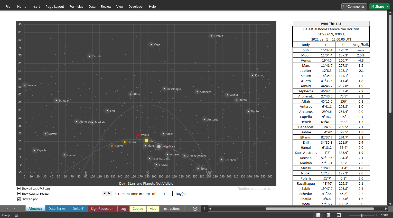
Perpetual almanac displays basic data necessary for celestial navigation
Sky chart showing traditional navigation bodies above the horizon
Option to show all 1,535 stars in the basic FK5 catalogue
Option to show the celestial equator and/or ecliptic
Printable list of celestial bodies above the horizon
Data series calculator for comparison/analysis
Rise, set, transit and nautical twilight calculator
DR and sight reduction calculator
Position log
Great circle route calculator including internal database of 26,571 cities worldwide
Internal delta-T values for dates between 500 BC and AD 2035
Custom delta-T value fields for dates outside the above range
Only 3.9MB
* Verified to run on current versions of Microsoft Excel only *


PostScript Plotting Sheets v4
Generates precise plotting sheets for any latitude/longitude
Customizable … turn the following features on or off:
Compass
Center latitude/longitude lines
Upper/lower latitude lines
Meridians
Latitude scale
Longitude scale
Can be used for plotting LOPs, radar contacts, solving maneuvering problems, etc.
Designed for use with U.S. Letter sized paper
Can be edited with any text editor, including Notepad
Recommended programs for editing/printing:
Rampant Logic PostScript Viewer
With PostScript Viewer, you can view, print and even save the plotting sheet as a .pdf


Declination?
SHA?
What does that mean?
The meanings of the terms used in celestial navigation literature aren’t always obvious. Here is a brief explanation of the coordinates used to describe the position of a star or other celestial body.

Herodotus tells us there was an eclipse on October 2nd, 480 BC.
This animation shows the topocentric altitudes and azimuths calculated by my spreadsheet. The altitude of the Moon is corrected for parallax using the calculated distance from the Earth to the Moon. The location is in the middle of the Sahara.